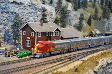
The SMRHS is building a model railroad in the Scottsdale-McCormick Railroad Park that represents how the Santa Fe Railway could have been circa 1959. The railroad does not try to model locations exactly, but hopes to capture the general look and feel of the real town’s represented that is within the limitations of model building.
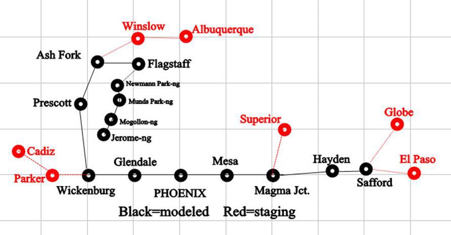
Historically the Santa Fe reached Phoenix via two branch lines off their transcontinental route from Chicago to Los Angeles. The first originates in Ash Fork, Az. It passes southward through Prescott, Wickenburg and Glendale to reach Phoenix from the northwest. This connects Phoenix with eastern destinations. The second branch departs from the transcontinental route at Cadiz, Ca. It enters Arizona at Parker and joins the other branch at Wickenburg. This is the route to Los Angeles and San Francisco.
Late in the 19th century the citizens of Phoenix chafed under the cloud of being the new territorial capital without mainline railroad service. The Santa Fe arrived on a branch line from its northern Arizona main line as did the Southern Pacific from its southern Arizona main line. Both lines terminated in Phoenix.
The movers and shakers in Phoenix coordinated with the Santa Fe to build a line up the Gila River Canyon through Hayden and Safford. This line would crest the continental divide east of Safford at 3500 feet, making it the lowest crossing of the divide in the US. The line would then proceed into New Mexico and Texas to join the Santa Fe lines there. This would give the Santa Fe a second transcontinental with a low-level grade that would avoid the long steep climbs required to cross northern Arizona. It also put the Santa Fe squarely in competition with the Southern Pacific, who fought the Santa Fe in and out of court for decades. Eventually the Corps of Engineers built the Coolidge Dam creating San Carlos Lake which blocked the proposed route, thus ending all ideas of running a rail line through the Gila River Canyon.
But we did it. In our 1950s HO world, Santa Fe had won in court and the Corps of Engineers never built Coolidge Dam. Our railroad runs from California to Phoenix via Parker, Wickenburg, and Glendale continuing to El Paso via Mesa, Magma Jct., Hayden, and Safford. There is a secondary line from Wickenburg to Ash Fork via Prescott that provides access to Albuquerque and the east. A branch line runs to Superior from Magma Jct. There is a connection to the Southern Pacific in Tucson via Magma Jct. Staging from Wickenburg to California, Ash Fork to Flagstaff and the east, Magma Jct. to Superior and Tucson, and Safford to Globe and El Paso are represented by staging.
Town by town, starting in the east, we find the rural, farming town of Safford. There we see typical farm related industries in an arid valley landscape. The lines from Globe and El Paso arrive here from staging. From Safford the line travels through the Gila River canyon with steep cliffs above and below. From time to time the river is depicted far below. At the outlet of the canyon we enter Hayden where the smelter dominates the scene. Many spurs feed the various functions of the smelter. The next town is Magma Jct., which has a small mine and a mining supply warehouse. The lines to Superior and Tucson branch off here. We arrive in Mesa, again with many agricultural support businesses.
Phoenix has a major classification yard and three industrial districts. At the west end of the yard is a section of downtown Phoenix which includes the Westward Ho Hotel. Alongside the tracks you can see the Arizona Brewing Company brewery much as it looked like in 1955. Glendale is next and is dominated by the beet processing plant which was modeled after the real thing. Other industries typical of small towns are scattered on both sides of the main. Wickenburg is at the other end of a short section of double track and has the junction of the line to LA with the line to Ash Fork. The industrial district is up a hill and reached by a switchback. A large coal mine dominates the west end and a sausage plant with stock yard is at the east end. Various small industries fill the center. The line then enters the Pea Vine, so called for the way it clings to the side of the hills like a vine. Prescott and Ash Fork are in ranching country, so stock pens and feed dealers outnumber the other industries. Ash Fork also has a small engine facility to handle the locomotives serving the Ash Fork to Phoenix route. From Ash Fork we can continue west to Seligman or east to Albuquerque.
Flagstaff is a large town with extensive dual gauge trackage to serve the interchange traffic between the standard and narrow gauge. Ore from Jerome, limestone, and cattle outward and ore from Superior, coal, oil, and supplies are some of the commodities transferred. Anyone switching the yard needs to use the idler car to switch cars of the other gauge to get them out of the way. There is also a large lumber mill. The narrow gauge climbs out of Flagstaff up on to the Coconino plateau and passes through Newman Park, a small farming community with a limestone quarry. Two logging transfers later, the narrow gauge enters Jerome which has the copper mine and smelter among its industries. The houses of Jerome are perched on the hillside above the railroad yard.
The railroad was built to represent the ATSF in Arizona during the steam to diesel transition period and operates under Timetable and Train Order rules out of the ATSF 1955 Rule Book. We operate equipment prototypical of that era 1955 plus or minus ten years.

